


Les Molieres B

philippebenne
User
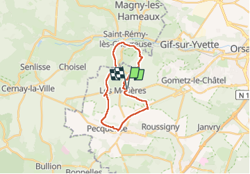

Length
20 km

Max alt
181 m

Uphill gradient
210 m
Km-Effort
23 km

Min alt
78 m

Downhill gradient
207 m
Boucle
Yes
Creation date :
2025-05-28 07:44:08.0
Updated on :
2025-06-25 15:20:17.191
5h12
Difficulty : Easy

FREE GPS app for hiking
 SityTrail
IGN / Geographical institutes
SityTrail Plus
The world is yours!
About
Trail Walking of 20 km to be discovered at Ile-de-France, Essonne, Les Molières. This trail is proposed by philippebenne.
Positioning
Country:
France
Region :
Ile-de-France
Department/Province :
Essonne
Municipality :
Les Molières
Location:
Unknown
Start:(Dec)
Start:(UTM)
431747 ; 5391415 (31U) N.
Comments